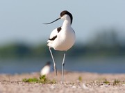
Location The properties are located on Kirr island, in a tongue of the Baltic Sea, between the mainland coast of Mecklenburg-West Pomerania and the Fischland-Darß-Zingst peninsula. Size 40,500 square metres. The entire Kirr island is 3.5 km in length and 1.5 km in width, covering 370 hectares or 3,700,000 square metres. Wildlife Important breeding area for 23 different kinds of coastal birds, including bank snipe, oystercatcher, pied avocet and peewit. Special features are eight breeding pairs of the dunlin and the only breeding pair of the ruff within Mecklenburg-West Pomerania. Flora Kirr island is dominated by goat willow, as well as hare's foot, sea plantain, red fescue, sea pink and sea club-rush. Background Kirr island belongs to the national park Vorpommersche Boddenlandschaft and is attended by the National Park Office. The purpose of the project was to preserve this important breeding site at the German Baltic coast. By purchasing a part of the private property on the island, the National Park Office will be able to further protect the breeding places of water birds and shorebirds. Special characteristics
The drowned grassland of Kirr island and its intact tideway system are remarkable peculiarities at the coast of the Baltic Sea, which is otherwise severely altered by coastal protection and land improvement measures. The island is submerged at high tides. The tideways, though, help to drain a major part of the water from the estuary. Nevertheless, some water always remains standing in pools or evaporating in salt pans. Kirr island was always used as a pasture. Centuries of floods and treading beasts, locking remnants of plants from air contact, created unique coastal flood mires on the island. Partner The National Park Office of Western Pomerania is a partner of this project. It administers the national park Vorpommersche Boddenlandschaft and the national park Jasmund. History An 'insule in Kyrre' was first mentioned in 1336. The modern name Kirr is recorded since approx. 1696 and signifies 'a place covered with shrubs or bushes'. The island was always used as a pasture. In the first half of the 20th century, there were two farms on the island, one of which has fallen into desolation since. The other is located in the east of the island. Kirr became an official bird protection zone in 1972 and a part of the national park in 1990. Concept for protection
The pastures are maintained by a landscape conservation company. Pasturing of the island by cattle helps preserving the flood saltmarsh grassland. Join us and help us to buy more land for nature! To our current projectMore about coastal birds and saltmarsh grasslandsMore about the Vorpommerische Boddenlandschaft More about the pied avocet

· Naturefund project info
Basic data: Kirr island
Share now:
Back to overview
